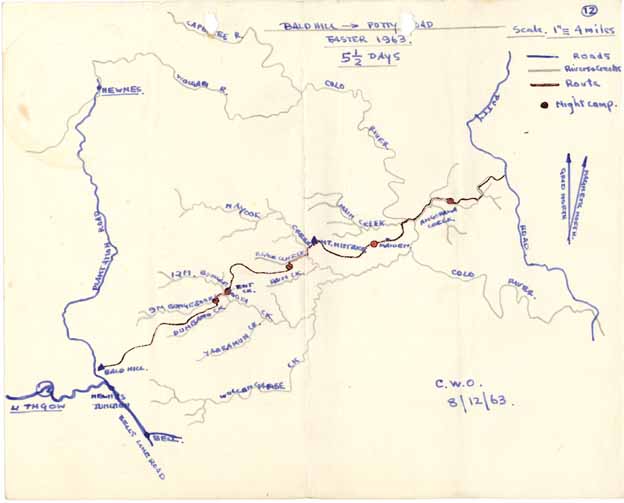
Bald Hill To Putty Road
by Colin Oloman
Easter 1963 (From SUBW Logbook 3)
Party: Peter Scott, Bob Masterman, Col Oloman.
Duration - 5 1/2 days.
Maps - Military sheets 1 inch = 1 mile. 50 ft cont. interval - "Wallerawang", "St. Albans"
The participants in this walk met rather haphazardly at Clarence on the Thursday night before Easter and retired gracefully to Oloman's house at Lithgow for the night. Friday morning at 8 am saw us up on top of "Bald Hill" surveying the hazy plateau that we were to cross; and so the great trek began.
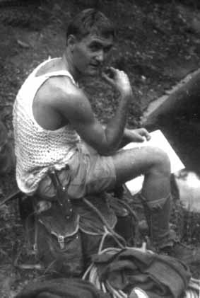
Above - Col Oloman, circa 1961, Photo from SUBW logbook 2.
With the 9 & 12 mile branch junction of Bungleboori Creek as our destination that night we took the old trail that heads east along the ridge from Bald Hill for some 2 1/2 miles, then cut off to the N. E. across a tricky saddle to the main ridge between Bungleboori (henceforward to be called B.b.) and the Dumbano creeks. The views of the B.b. from this ridge are quite spectacular, characterised by great castles of weather beaten sandstone, above the shear dissected sandstone gorge fed by many 'canyon like' tributaries. Progress along this ridge is quite tricky as the ridge rises and falls in a series of hillocks and narrow confusing saddles, the whole being covered by dense saplings and prickly scrub. Navigation through this country requires the constant reference to map and compass (every five minutes or so) and any mistake usually results in the party standing over a deep gorge and not knowing whether the saddle by which they were to cross it is to their right or their left.
The day was hot and "Eastern Scroggin Time" was very welcome and lunch time most essential. Although the ridge top here is generally dry, the occasional open saddle affords small tributaries which if followed down for a hundred yards or so will yield an abundant water supply for thirsty walkers, in deep, clear sandy bottomed pools. We had lunch on one of these.
In the afternoon the procession continued its scrub crawling, saddle searching, cursing and rock sitting until almost sunset. By this time we were well flaked and some two saddles from the B.b. junction, so rather than risk going further along the tops with a possible hairy descent around nightfall we decided to take the nearest tributary into the B.b. The descent was absolutely CHUNDEROUS with scrub, slippery logs, ferns, mud, insects, small waterfalls, but luckily no large "rope type" drops. We reached the bottom to find more scunge and a large sandy B.b. creek, no caves, no flats, no firewood, so we had a quick swim, cleared some hillside and lit a fire in a dry creek bed. After a scrumptious steak tea (à la Masterman) we flaked in various contorted positions around rocks and tree stumps.
Saturday morning was bright & beautiful and the two mile walk down the B.b. quite pleasant (of course we soon found some terrific campsites). The B.b. here is generally flat with pleasant myrtle clothed banks, vines and rotting trunks. There are no real waterfalls but occasional steep rapids with associated boulders and difficult negotiation. A walking rate of 1 map mile per hour is reasonable going.
The B.b.'s junction is very impressive, especially viewed from the tiny saddle on the upstream side which we crossed as our quickest route. The gorge here is somewhat like the Upper Grose with a maze of shear sandstone walls on all sides. The creeks are fed by a series of steep tributaries, most of which appear negotiable with some climbing. The problem of getting out of the B.b. gorge was now considered seriously. Although the Valley of the Swamps had been our planned route, a small tributary more directly in our path seemed quite promising.
After a comfortable lunch on the banks of the 12 mile B.b. we began to climb the slope zig-zagging across rock terraces to the base of the cliff proper. Facing uphill on our right lay our tributary (hereafter called "Exit" creek). Edging around the base of the cliff we were able to miss a 40 foot waterfall and rounding the corner found ourselves facing a lovely blank wall some 50 feet high. However as we came closer we found that the wall was simply a large chunk of rock wedged in a canyon. The creek flowed out of a dark hole beneath the rock and following through a short tunnel we came out into a smooth walled amphitheatre into which cascaded a 20 foot waterfall. A freehand go at this waterfall was unsuccessful but we soon had a couple of pitons driven into the wall. With a bit of clawing and sling dangling this first fall was beaten, only to yield to a deep pool and another waterfall. However a bit of stretching and scrambling led to a ledge that led around to the lip of the amphitheatre. Then a half hour looking for a place to insert another piton and up and around into a scrubbly gully (sigh of relief). A rope down over the top of the chockstone gave Bob and Pete a good chance to show their hand over hand climbing techniques and brought us all out above the amphitheatre. From here we ascended by a zig-zag path up the broken cliff face until we were stopped by nightfall and forced to camp in a small cave on the cliff, a few feet from a delightful drop into the B.b. Much discussion ensued that night on how we should best use our two bottles of water. With drawn knives we shared the water, while down some three hundred feet below and but two paces away the B.b. gurgled sensuously into the night.
On Sunday morning some bright young Scott suggested that we might be a bit short of pitons, but as there were three, solidly embedded in the rock two hundred feet below, this really presented no problem. Just a quick before breakfast jaunt down to the pit, a 100 feet of rope belayed on a tree, a quick abseil, and presto, bang, bang, bang, bang .... ! Ugh!! .... bang, bang .... B.b. ..... bang. Meanwhile dangling in waterfall .... B. ...... b. the pitons were retrieved. All we had to do now was retrieve the sucker who got them.
Eventually we got under way and after a couple of false "summits" followed by delicate climbs -- up one of which Bob M. demonstrated the "inverted pole cat" technique and finally dragged us up on long lengths of rope behind, we reached the summit and looked back across the B.b. & environs. This was a really magnificent view of the flat, tree covered, plateau cut by creeks into huge rocky slabs like some giant haphazard sandwich cake. At the ridge ends the trees disappear and the cliffs tower up into great monoliths of tiered sandstone that look over the twisting gorges. Breakfast was a short distance away on a pleasant clearing above the 'Valley of the Swamps'.
This day was again spent with map and compass in hand scrub bashing the ridge tops to follow the contortions of those two top contour lines from B.b. to the southern ridge of Black Cliff creek. By evening we were descending (dead on course) a small tributary into Black Cliff (B.C.) creek, but decided to camp under the first cliff line when we struck a two rope waterfall.
After spending the night in a large sandy cave we reconnoitred and decided to continue down the tributary as our best way of passing the imposing cliff line on B.C. creek. In daylight the descent was easy - two abseils and no canyon.
The descent of B.C. creek to the Nayook creek was relatively easy as we followed a smooth shelf of sandstone (pitted by deep potholes) along the creek bed. Occasional difficult sections slowed us down to some 1 1/2 map miles per hour. All through that morning we were becoming alarmed at the critical state of Pete Scott's shorts, which were being kept up by a piece of string or something. Suddenly, just as we were clambering down a shelf, it happened, and we turned back in blind panic as Pete cried out in a choked voice "The party is doomed" and strode out onto the flat with his shorts falling around his knees. Oh truly, a soul shattering experience.
Gathering our nerves we struggled on to the Nayook and B.C junction. Here we were rather put back by the sight of some hundreds of feet of cliff over which we were scheduled to pass. A thorough squint at these cliffs showed no useful route (a couple of nice waterfalls) so we cut upstream under the northern cliff line - hoping. About 3/4 of a mile upstream of the junction a small tributary cascading into the gorge looked promising. We looked around for a while and Bob M. eventually found a way out which involved some climbing and pack hauling but was really very fortunate. On top of this second gorge we looked back & gloated over the impressive chasm which we had just crossed -- then on and up to lunch and then the summit of "Mount Mistake". From "Mount Mistake" we headed east to follow the ridge that runs down between the "Main Creek" and the Wollangambe Creek, across the "Maiden" and into the Colo River. This ridge was once again tricky to follow and very densely scrubbed. We had set our hearts on sleeping on the "Maiden" that night but due to the difficulties in the country found ourselves at nightfall threshing and stumbling across an absolutely rotten hilltop just solid with saplings about 1 mile before the "Maiden". In semi-darkness we made our way down to flat piece of ground and were lucky enough to find a small cave just under the hilltop, before it became quite dark. The nearest creek was a couple of hundred yards away and protected by a narrow cliffline - the only pass being full of barbed vines, but we managed to grab two bags of water and spent a comfortable night in our cave. We were content that night to sleep next to the Maiden.
On Tuesday morning we continued along our ridge, which became more scrubby and rocky and generally distasteful to such critical bushwalkers as we were, as we progressed. The climax of the morning was of course the ascent (or if you like, the "mounting") of the Maiden. One could hardly say, though, that her embrace was gentle. Indeed she was like a tiger in our arms, fighting us at every step. It was only when we arrived at the summit exhausted, that she yielded to us and showed us a delightful panorama of the Colo Valley and allowed the cool morning breezes to caress our brows.
Descending the Maiden we attacked the ridge again until we had reached the last tributary into Main Creek before the Colo River. Anticipating a solid cliff front to the Colo we decided to descend this tributary in preference to following the ridge to the end. This was a good decision as the tributary was most pleasant - a very steep shelving descent to bare rock that was a pleasure to walk down ended with a short abseil into Main Creek.
Half an hours walking down Main Creek brought us to the Colo River. The Colo is quite a magnificent river just here. Set between high sandstone cliffs similar to those at Glenbrook Gorge the river itself was some 30 to 50 yards wide (no recent rains) flowing over rocky rapids into deep sandy beached pools. Blackberries and nettles mar the otherwise pleasant appearance of the banks which are covered with silver wattle trees, and of course make walking along the banks quite difficult.
We managed to cross the Colo without getting wet and had lunch at the Angorawa Creek junction - a delightful spot with excellent swimming facilities. Angorawa Creek proved to be an easy walk for most of the afternoon and very enjoyable. Somehow there have been formed a series of smooth sandstone terraces down which the creek runs. Each terrace runs for up to a hundred yards and is connected to the next level by a waterfall which may be up to ten feet high - a real joy to walk along. Towards evening the going became tougher as the creek deteriorated into a typical rock hopping, tree swinging exercise and we finished up camping at nightfall on a small patch of sand about one mile below the "first fall" on Angorawa Creek.
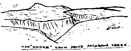
We reached the tributary about 3/4 mile below the "first fall" on Wednesday morning after about 1/2 hours walking. This spot is an excellent camp-site and bore marks of previous occupation in the form of a Huttons sausage skin. From here we forsook Angorawa Creek as it was becoming rather chunderous, and took off over the left hand ridge to "Angorawa Swamp". From the top of the hill we were able to look back towards Mount Mistake and for the first time we saw our beloved Maiden in her true perspective. It was easy to see how this hill achieved her name but since we took no photographs on this trip, let me draw what we saw that crisp morning.
After a slight blunder which gave us a bit more climbing we reached the Angorawa Swamp, a pleasant little valley which seems to have been used by timber-cutters. At this point we had lunch, deciding that since we were so close to the Putty Road we had better finish off our provisions. Wow - wot a beano of bread & cheese, nuts, rullah and sweet rice pudding.
Following the track up the "Swamp" we walked contentedly for two or three miles until the track gave out in a morass of vines and thick ferns. At this point, being so close and yet so far from the road our bright conversation degenerated into vile cursing as we were forced to leave the last track and climb up onto the ridge through a net of prickly vines. But the Gods were kind for another half mile of scrub crawling that neatly removed the few remnants of unscratched skin from our legs and hands brought us to the road - the ROAD, the ROAD, the ROAD - Ah Joy!! We knelt and kissed its shiny asphalt surface and knew the joy, the ease of conscience that comes to men who know that they have done their duty. We had crossed the B.b, the B.C. the Nayook, the Colo, Mt Mistake, the Maiden, miles of leg ripping ridges, thousands of feet of hills and gorges. Yes, at last we had crossed that B.:...b:.... country.
Fortune was with us again when a kind truckie picked us up after we had been hitching for about 1/2 hour, and gave us an interesting trip into Windsor where I hopped out whilst Bob & Peter went on to Homebush. We didn't have our much discussed stout together - but then we couldn't expect everything.