Recollections of the 'Sixties in 'NinetySix:
The Whys Of The Kowmung Country And Gundungura
A Tale of Maps by G.E. (Geoff) Ford
Prelude
Since returning to Sydney, I've been parrying requests to explain the Gundungura map of the Kowmung Country which I produced while at Sydney Uni. An article for the 50th Anniversary of the Sydney University Bush Walkers (SUBW) is as good or better way as any other to do so. I won't cover route notes which are dealt with in the Gundungura booklet.
Some of my recollections are reinforced by seeing transcripts of our journal entries. While Walks Secretary of SUBW in the late 1950s, I set up a log book system similar to that of the Scouts in the Sydney Uni Rover Crew (SURC). (But that's another story!) Thanks to Wyn Jones for showing me a transcript of the walk in the original SUBW handwritten log book which he is holding. Wyn drew attention to a log entry, just 30 pages later, that Geoff Ford was "nearly strung up for the midnight Easter walk" referred to in this article. Make up your own mind.
The whys of, or explanations for, the Gundungura Map lie in the characters of two great figures who shaped bushwalking history, Myles Dunphy and Frank ("Paddy") Pallin. Read on.
Background
Why should Sydney Uni students occupy time with map making when they could be studying (or touring; or bushwalking; or climbing; or canyoneering; or canoeing; or caving; or just camping - and cooking magnificent goulash)? Take your pick of these answers....
1) Myles Dunphy as a cartographer was a great source of inspiration - I spent endless time living in the folds of his 1953 Gangerang bushwalking sketch map.
2) Paddy Pallin as a counsellor was a great source of encouragement - I was among the scores of eager people who came to him in the 1950s for information.
3) The only map available covering the rugged country of the Greater Blue Mountains in the 1950s was the 1930s Blue Mountains and Burragorang Valley Tourist Map. It was Dunphy who spent a year draughting particulars on the black and white version of this map so it could be used by walkers. Topographical, ordnance maps of the area did not exist.
4) Myles Dunphy, an architect and consummate recorder, declined to complete for distribution a map which detailed what I came to refer to as the Kowmung Country.
5) Paddy Pallin offered to publish a sketch map if someone produced it.
While all the preceding answers are true, the real reason is that I, and some mates from SUBW and SURC, had to walk 5 days to complete a 4 day trip on that epic walk, Easter of 15-18 April 1960. We had referred to Dunphy's 1939 sketch map for the Kanangra Tourist Resort, and his map for the Bindook Primitive Area published in 1937 when he was 45 y.o. Read on.
Introduction
Outdoor enthusiasts at Uni were a very strong group considering the constraints of the late 1950s. We were familiar with the Blue Mountains: the vicinities around Kanangra Walls, the Three Peaks, and so on. Who would believe a generation later that our traditional travel then was by public transport or hitchhiking - even on our first trip to climb Tasmania's inaccessible Federation Peak? (But that's another story!) Can you imagine now riding in the sooty Fox coal trucks through the Burragorang Valley?
With the discovery that we could hire passenger vans to go climbing, those travel constraints had an affordable cash solution. We hired two VW Kombis for the Warrumbungles. (But that's another story!)
In 1960 I was in 4th year Vet. Science. Since by then I had become leader of the Uni Rovers and walks leader of the Uni bushwalkers, I put on the biggest trip of which we'd thought. We had venturous leaders to do this. People like Col Oloman, Warwick Beddoes, Peter Hinton, Don Westerway, Bob Masterman, and more.
We'd not long started canyoneering by abseiling with rucksacks (classic style, in shorts of course) down Arethusa Canyon, in order to go camping and swimming at the Grose River in Blue Gum Forest after the end of year exams. (But that's another story!) So, some thought Easter also called for an easy trip, lazing on the banks of a river.
Yet some others wanted a tough trip to explore for more canyons. I'd become fascinated by Myles Dunphy's sketch of Bindook Chasm. A couple thought of taking advantage of the darkness of caves. Why not Colong Caves? But the road in to Colong and Bindook was closed as the Burragorang Valley went under the waters of Warragamba, while the government stripped the trees from the hillsides before the rising flood of Sydney's greatest water supply. There were tales of armed patrols hunting bushwalkers from the catchment. A challenge not to be missed. (But that's another story!)
For now, a base camp on the Kowmung River was clearly needed, providing lazy camping as well as access both to Bindook and to Colong from Kanangra.
The Plan; The Start
Several students, from the Uni walkers and Rovers combined, would register with a hire firm to share the driving of a Kombi. We'd take the legal number of people (then eight), and do several shuttles between Kanangra and where the rest would assemble, arriving by our traditional travel means. But only Don and I turned up... so one of us had to drive at all times. We were not surprised - on a recent Uni trip the Kombi driver had tried to cross a deep creek by steering alongside a bridge rather than over it. (But that's another story!)
On arriving at Katoomba, Don and I extracted out of the cafe as many more waiting people as we could fit in with their packs. Can you imagine how little room there is left, even in a Kombi, when there are twelve rucksacks packed for a 4 day trip? Then add the twelve people!
The background chatter level was overwhelming. So was the stunned silence on the steep Victoria Pass when the laden Kombi hurtled off the road up the safety ramp! I got the respect the driver deserved after that.
This first lot was dropped off at Whalan's hut Thursday night, while I went back for the other nine. The hut was full. More cramped up in the Kombi, as the weather turned unpleasant. Nicely, Liz Scott had pitched my tent for me to stretch out, choosing the greenest spot. Great! By dawn I was floating down a grassy rivulet.
Into The Kowmung Country
Christy's Creeks
We planned the first day to split up and reassemble at the junction of Christy's Creek and the Kowmung River which was to be our base camp. The easy walkers, planning on lesser exertion, set off along the obvious route, down Colboyd Ridge. The intrepid walkers tried what was thought to be tougher, around Myles's Chasm, crossing Middle Christy's. Then down Wallarra Ridge, to follow the creek from its junction with West Christy's. But by bed time Friday we were not all at the base camp. Remember, this was before the availability of walking notes or maps.
As we had breakfast on day two, Peter came into camp to report the easy party was up the creek, scratched. They'd done it hard, descending into what turned out to be the difficult Middle Christy's to extract themselves from some thick scrub after Mt Colboyd. At least they'd got out of the wind.
No wonder route notes in the SURC Gundungura booklet became so popular. We didn't feel so bad: It was difficult even in 1914 when Dunphy went through the Kowmung Country on his 23rd birthday - when there were more prospectors' and cocky settlers' tracks with cattle and horse trails. He had started his vacation exploration of mountain trails two years before with only surveyors' parish maps. We at least had his information on the tourist map.
Big Rick
Day two, eight of us leaving our base camp, up to the Big Rick (Mt Colong), straightforward enough following a ridge on the tourist map (Armour Range). The trig pile was the most gigantic cairn we could imagine, a little peak itself. We were now on Dunphy's Bindook sketch map. He had lots of features named Coolong, which then was confusing: There is only one word, officially spelt Colong, which is pronounced "Coolong". It's origin is intriguing. (But that's another story!) Dunphy's thoughts on it in 1966 were sent to the SURC.
Following the Bindook map became interesting. We had planned to use it to reach Bindook Chasm that day. But someone had rearranged the topography so that it didn't fit the map. The creek flowing south did not come off Kooragang Mountain. The well marked Barrallier's Track up Red Coats' Valley was not there. The head of Bindook Creek was the head of Lannigan's Creek.
Bindook Swamps
Day three was time to return to base camp, via the remains of Yerranderie settlement, abandoned when cut off by the Warragamba flood. Col took off with half of us to do just that, seeking the company of the goulash, (or was it the girls?) lazing on the sandy banks of the river.
The remaining four of us had less sense. Strange, none of the survivors wanted to come roping with me down Davies Canyon for a long weekend two months later. But now, they still agreed to eyeball Bindook Gorge. So we dropped our bundles, and headed off by compass after we recognised the attractive Painted Gums identified by Dunphy. A prominent cliffy knob projecting like a grand stand above the land was a blank on the map. We learnt a lot of the Bindook Highlands and its swamps before getting to gaze into the Chasm itself. We'd made it.
By the time we got back to our packs we were 8 hours behind the others. You could agree that the chances were low of catching them and getting to base camp on day three.
Colong Maze
By the time we'd confirmed there was no track in Barrallier's Pass where the map had shown it, and we'd eventually reached the deserted Colong homestead, the sunlight was going. By the time we were finding a way around the Little Rick (Square Rock), it was too dark to see. By the time we'd crossed the Coal Seam (Colong Gap) and reached the ghost town of Yerranderie it was eerie. By the time we reached the Tonalli River crossing the moonlight was coming. We had a midnight pause. It was a magic interlude. It led to my claim that the whole thing was worth while. By the time we were heading out along Scotts Main Range we knew we had the trip in the bag. We'd done four full days' walk already. So we watched for the dawn at the Bulga Range junction. After all, the others could not leave us behind, because the only Kombi drivers had both gone to Bindook!!
Kowmung Camp
We had great expectations of dropping off the Bulga Range into the base camp and being welcomed by the cheering crowd. And a goulash for breakfast. But the advanced four, arriving the previous night had convinced them we probably wouldn't be coming that way. They'd all had their own adventures and were ready to go.
Overall, we'd had 4 parties of four exploring, and a 5th of five who lazed. The caving party had had trouble with the route to Colong Caves too. The track had become overgrown since the Warragamba flood had removed the visitors by cutting off the access through Yerranderie. Instead of the seclusion of the cave, Peter and Liz spent the night among stinging nettles of Green Gully!
The main mob had left the base camp an hour ago to follow the river downstream for 8 or 9 loops to the track up Roots Ridge shown on the current Gangerang map. This accessed the Gingra Range track to return to Kanangra Tops where the Kombi had been parked. The fastest, fittest, rested walkers had waited for us just in case, but even they had gone. Col's note showed we had only just missed them. Making the decision whether to keep going to catch up was easy.
We Bindook mob stopped for a hot cooked brunch with a swim and a couple of hours rejuvenation.
The Bluff
With our experience of Dunphy's Bindook map, we looked at his Kanangra map with a new perspective. Bullhead Ridge towering above us was labelled "Very rough" and "No way off". I chose to test it. Success would save several hours. But if Dunphy was right, we'd be eating our emergency rations. Don chose to agree with Dunphy and therefore continue downstream, thus expecting to miss the Kombi return to Katoomba if I got through first. No problem: Don could walk to Katoomba in only 2 days. And he did.
That left a single driver with the Kombi key. Me. We had to get up above the magnificent cliffs of Sunrise Bluff and cut off the tail of the main mob coming around the long way. And we did.
A load of people were feasting at the end of the road when we got to the Kombi. They had taken a short cut route up Brumby Ridge. It was past dusk. Not long after, the last group, who had come along Gingra Range more slowly, returned.
We had had intercourse with the Kowmung Country and we had been inspired.
Conception
The Consequences
Uni bushwalkers were known for bushwalking. However Uni Rovers were known for service (don't ask). Even intrepid walkers who'd been to Bindook could benefit from maps. I absolutely revered the image of Myles Dunphy. I was 20 y.o., he was 68 y.o. I contacted him:
His drawings were superb. Did he propose to produce a Kowmung River map like his Cox River (Gangerang) map? --- No. Not at present.
All we wanted was a map to use.
Did he plan to revise his Bindook map? We'd be willing to help if needed. --- No.
Did he mind, then, if we put out some sort of sketch map? --- Rubbish. It had taken him years. Mere Boy Scouts who were only young students from Sydney Uni would never be able to do such a map.
And so our Gundungura project was born.
The Mapping
The project thrived, with encouragement from Paddy Pallin, who was then a young 60 y.o. Myles had been the midwife, Paddy became the nursemaid. I had known Paddy since I was a little boy, going around to his garage with dad to get dried carrots from army ration packs. (But that's another story!)
Paddy also got me to do a sketch map connecting Dunphy's Gangerang map to Katoomba. The missing link of the Narrow Neck which Myles had avoided doing for distribution. I called this 1961 map Nelly's Glen. It was done about the time the government had been bulldozing fire roads in the bush. There are vivid memories of Rick Jamieson's brakeless car topping a ridge in the black of a Friday night with no visible track ahead. (But that's another story!)
Kanangra was anglicised spelling for the name of the Aboriginal tribal group of the area. I was also working with Fred McCarthy, then Museum Curator of Anthropology. I discovered the spelling Gundungura now presented the sound of the name better. We decided to make it the Gundungura project, to recognise the previous inhabitants. This had another advantage, of distinguishing our map of 200 sq miles (500 sq kms) from Dunphy's Kanangra map.
I started with the parish survey map showing Yerranderie Gold Fields. We learnt about minerals and fossickers, we learnt about cedar and timber getters, we learnt about the Camden stock route and drovers, we learnt about peacocking and selectors, we learnt the rugged country had been occupied by rugged men.
I spent days and days at the Lands Department where I was granted research access to aerial photographs. It was a precedent. In those days they were not readily available. They had them to prepare their own maps of the area, which were published in 1965. Now, anyone can walk in off the street and buy aerial photographs over the counter!
As well as continuing an active program elsewhere, many of us spent vacation time, and weekend after weekend through 1960 and 1961, walking around Kanangra and around Yerranderie. And that's lots of other stories! We swam through the deep gullies and gorges. We explored the caves with the speleos using carbide acetylene lamps. We challenged the cliffs and peaks with the rockclimbers. We placed a SURC visitors' book at the fabulous view on Yerranderie Peak. We used for our main base, Batsh Camp.
There was not a German called Batsch as some tales tell. There was no bat camping at the site. Simply, the camp was that where the bags of bat shit were carried up the ridge from the caves. And then carted out along the track for fertiliser. Can you imagine men of the Great Depression calling something Guano Camp? But in the 1950s and 1960s the printed letters i and t after s and h were not sociably acceptable for a publication. Notice what even happened to the sh we put on the 1st edition. "They" took off the h as well as the it!
We became friends with Neville Lang of Bindook and Colong Stations. He made the project live with local and historical knowledge, and drove us around the dingo traps. At that time the stock route from Oberon was just a rough track. It was put in by the locals after access through Yerranderie was cut off by the rise of the dammed waters in Burragorang Valley. (But that's another story!)
Big Rick Jamieson was the mainstay in the bush, keeping me going and contributing to the field work. He provided constant unreliable transport. Engineering students' cars, especially 1931 A-model Fords, always need attention. (But that's several other stories!) A law student, Don Taylor, was the mainstay at Roseville, keeping me going and contributing to the draughting work. You can see their names on the 1st edition. The 16 Uni students who assisted in some way with the project in 1960-61 are recognised with their initials along the bottom of the 1st edition classic.
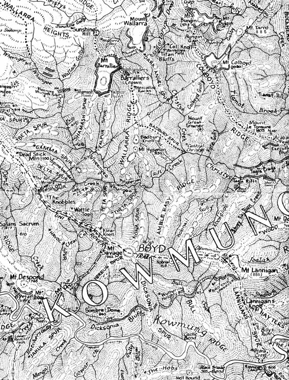
Above - A small section of the Gundungura Map
The Booklet
The Gundungura booklet was to come, over 10 years. SURC members carrying on did a mighty job producing such a useful publication. (But that's another story!) It has provided background for other articles. I had planned it to be a comprehensive pocket book to be carried in the field. It was to include a glossary explaining every place name. And information about animals and plants as well as archaeology and minerals. We collected together lots of historical and scientific information in the Uni Rover den. Its concept was modelled on "Snowy Mountain Studies", edited by Charles Warner. That was an outcome of a committee on which I was an activities adviser, convened by Paddy Pallin for a Senior Scout Venture near Mt Kosciusko. (But that's another story too!)
(There are now more publications on the Gundungura area. Books following Athol Abrahams' SURC compilation, by people like Jim Barrett and Jim Smith, are a good read. And there's lots of original and retrospective stuff in the collection by Patrick Thompson.)
The Trail
Another outcome of the Easter 1960 trip was to do something to make Colong Caves accessible to speleos and bushwalkers again now the access from Burragorang was cut off. So, at the same time, where the mountain trails of Dunphy's era had become overgrown, we identified the best route. (But that's another story!) Dunphy's response to this Scouting service was to call the aluminium markers tin tags. He who had blazed trees, followed bridle trails, carried a rifle to shoot game, put out a comment on our trail "Bushwalkers do not want routes marked all over the country."
Subsequently, the Geographic Names Board and the Central Mapping Authority (Lands Department) recognised our route as The Uni Rover Trail.
I was disappointed that Myles Dunphy relocated the name of his Lost Rock to my Revelation Rock. In 1914 when lost at the top of his Misery Ridge, he had climbed a rock for a view. It took all morning to find the cattle trail he followed down the Boyd Range. In two well manned mapping expeditions in the early 1930s he had not plotted the Lost Rock at the Revelation Rock. The real rock where Dunphy was lost and found has considerable historical significance: It could be considered the foundation place of bushwalking, and bushwalking sketch maps.
Revelation Rock had particular significance as the place of revelation, because it had become very difficult in the 1950s to find the start of the Boyd Range. The rock was the place from which the way off the Boyd Plateau onto the Boyd Range was revealed when surveying for the map. It was the key to the new route to Colong Caves, so we placed a SURC visitors' book there. The original Uni Rover Trail went across this lookout to give walkers that perspective.
Dunphy published his statement (inter alia): "This ... country ... will terrify the incompetent. Hikers and Boy Scouts should not attempt ..." And to think we had imagined we were on his side. Myles led the push to separate the true mountain trailers from all the rest. It was when he had got home from that 1914 expedition that he formed the Mountain Trails Club with two friends - hiking, which then included bush walking [two words], was for the less accomplished.
While Dunphy made the mountains frightening, Paddy Pallin made them friendly.
The Words
With Paddy as our mentor, the map progressed. Bits of sketches and other data appeared in the Uni Rovers' den and around my parents' dining room table at Roseville. And the 1st edition looked like it!! We wanted to use place names for bushwalkers to identify features, rather than "go up the third spur past the bend in the creek where the tall tree is" sort of stuff. I approached Myles Dunphy again:
His names were inspiring. Could we use the ones on his maps? --- Students would never be able to do such a map.
Well, already we'd located and plotted his features around Kanangra and Bindook. We didn't want new names, we thought his were superb. OK? --- He'd consider it.
Now, even Myles the Magnificent, my progenitor, was starting to take notice. I'd got the sketch done covering what I was to call the Kowmung Country. Did he have names for features there too? Could we use them and attribute them to him? Could I show him the map? The response tarnished the image of my idol. He was human after all. There was no more availability on attempts to contact.
Dunphy was skilled in using descriptive names that captured the imagination. And he used names like Misery Ridge for a one off description of the weather on his own trip in 1914. But also he used names of people in his club, friends and their relatives. So we adopted place names most compatible, either with Neville Lang's stories and historical use, or with the description from our exploration and the topography. The glossary was kept with the Uni Rover records.
Readers will be aware that even modern official government Central Mapping Authority maps carry the message that place names on the map are not necessarily approved names under the Geographical Names Act 1966. They do not have to be.
Within a year of Paddy publishing the SURC 1962 Gundungura Map of the Kowmung Country, Myles had produced some partial revision of the Bindook and Kanangra maps, sharing our research. And he completed a Kowmung map for distribution after all. From that stage he became Myles the Munificent.
All we had wanted was a map to use.
******
Endnote
The SURC is no more. (And that's another story!) The search is now on to recover the Uni Rover records so that they can be properly stored in a public archive. It is hoped that the records of the SUBW will be archived in the same place. The Mitchell Library seems the preferred situation, in comparison to say the Fisher Library.