What I Did Last Xmas
John Atkinson
What I did was a nineteen day trip in Nelson Lakes National Park in the northern part of the South Island of New Zealand, basically walking from Lewis Pass on Highway 7 to St Arnaud on Lake Rotoiti. Much of the walking there is through beech forest on marked and maintained tracks with lots of huts. As one might expect, this aspect of the trip though scenic was boring and a waste of time, but I wasn't in a hurry and was able to make a few worthwhile side trips.
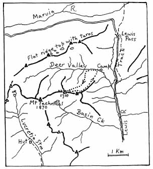
EXCURSION 1: TOWARDS MOUNT TECHNICAL.
When the bus dropped me at Lewis Pass, I reckoned I had a few days to waste so I walked south a kilometer or two to Deer Valley and set up camp in the beech forest beside the creek an hour or so in from the road. It was already raining and kept it up all night and all the next day and all the next night. I read one and a half of my three books and tried to keep a plague of mice out of my food bags with only partial success.
The following day it cleared up, sort of, but was very windy. I set off about midday heading upstream to see what Mt Technical was like. It was fairly slow going, a good reintroduction to steep NZ beech forest. Eventually I came across a clear lead where an avalanche last winter had swept away the trees and headed up it to the treeline. I came out of the bush into one of the nastier patches of subalpine scrub around, and it took a fair while to cover the next couple of hundred meters, but after that it was just snow-grass and some scree, sidling up so as to reach the crest of the ridge as it rose to the peak on the horizon, just steep enough so that it was nice to have my axe with me.
On poking my head over the top however I was hit by the full force of the southerly. Also, the peak wasn't Mt Technical at all, which was a kilometer or two further south-west along a narrow rocky ridge. It had steep snow slopes on the south face, and fairly steep rock everywhere else that I could see. Quite technical in fact. It was clear that I wouldn't be able to get there, not in sandshoes in that wind which was too strong to stand up in. So I followed the crest to the last bump of the peak I was on, then turned back.
I decided to stay near the crest of the ridge on the way back and to follow a spur at the end which should come out not far from my camp, thus avoiding a good bit of scrub. In this I was fairly successful, except that where I hit the creek there was quite a large flat which I hadn't seen going up, so I concluded I was downstream of my camp and headed upstream. Of course I wasn't, and after half an hour I turned back downstream, finally reaching my fly just on dark at ten o'clock. Another wet pit-day followed.
EXCURSION 2: FAERIE QUEENE VIA CAMERA GULLY:
Two days later I was at Ada Pass hut, just south of the Spencer Mountains. The weather was fine and cloudless and, as far as I could work out, Dave and Bean probably wouldn't arrive till two days later. The thought was that we would then leave the St James Walkway and head north-west over into the Matakitaki valley. I thought it likely that the others might want to climb Gloriana Peak, which was (more or less) en route, so I decided I should go up on to the range somewhere else and try for the Faerie Queene, which is the next peak along.
Camera Gulley is a largish creek heading up on the eastern side of the Spencers from the Ada River five kilometers the other side of Ada Pass, between Gloriana and Faerie Queene. It occurred to me that we might end up crossing the range by this route (rather than north of Gloriana), so I took up most of my gear, leaving only food and reading matter at the hut.
After a couple of hours of track, I walked down through open beech forest to the river, waded across, and headed across the delta of the gulley opposite. Rather slower here, windfalls and low scrub. I finally hit the creek near where it steepened at the foot of the slope. The banks were mostly grassy, with some low scrub. About halfway up, there was a big waterfall, avoided by taking an obvious creek up to the right half a kilometer or so downstream. I skirted around a patch of beech forest, which would be the only place around sheltered and flat enough to make a good campsite, then crossed a spur and was back in the main creek as it veered to the north-east. I continued up, sidling on steep snowgrass and subalpine scrub. Eventually the creek bed became a snow gulley, which I skirted round until I reached the end of the grass, where I dropped my pack and started looking around for somewhere to sleep. I soon found one or two ledges large enough for a sleeping bag. No water though (apparently no snow on the ridge above to melt and run down), so I collected a billy of snow and left on a rock to melt.
It was only five o'clock, so I decided to head up the snow slope ahead, making steps for the climb the next day and sussing out a likely route. Dispite the hot day, the snow was firm and I made good progress. At the top of the lower slope I moved up on to a patch of rock. After a drink of water, I followed the rock up to where it became snow again, then headed up and to the right towards the a spur which looked like it was mostly snow- covered all the way to the main crest. After an hour or so, with the gully up to the spur becoming a bit steep and the route above beginning to look less likely, I turned back. Although the snow looked glissadable, I cautiously walked down most of the way, only glissading the gentler slope below the rock, and got back to my pack about nine.
Next morning saw a fairly early start, delayed for a while when I reached the snow and found that I'd forgotten to adjust my crampons back to fit my climbing boots since the ski trip with Bob Sault two or three years before. Ofcourse I didn't have a screwdriver, and a piece of rock made a poor substitute. However eventually I was off again, cramponing up my old footsteps, avoiding the rock and following the snow all the way this time. There'd been a good freeze, although the top layer of snow soon softened when the sun hit it. Instead of sidling off to the right, this time I kept on straight up, crossing a bit of rock and then zigzagging up the upper snowfield to the main crest, a total of about seven hundred meters of snow climbing. Being on my own, I took it easy, and it was mid-afternoon before I reached the main divide at a peak halfway between Gloriana and Faerie Queene.
I ate lunch, took off my boots, dumped my pack and climbing gear, and set off in sandshoes along the ridge. Pretty easy going, rocky, scrambly in patches. It would be very easy to reach the ridge from the north (Matakitaki) side, with plenty of tarn campsites not too far down, but there were no obvious routes on the Ada side much easier than the way I'd come. Given a few days of good weather, a traverse of the whole Spenser Range would be a worthwhile trip -- you'd probably be able to keep on or near the ridge a good deal of the way. Anyway, after a couple of hours and a kilometer or so of rock-hopping, I ended this particular excursion on the summit of Faerie Queene.
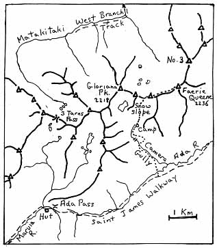
I returned the way I'd come, wearing crampons most of the way down. It would have been a great glissade if I'd been game (also a couple of hours quicker). During the night the wind came up, blowing my snow-filled billy off its rock never to be seen again and making sleep impossible. At first light I headed down, stopping on the meadow at the top of the beech forest spur for a late breakfast and a few hours lie down, and reaching the hut mid-afternoon, an hour or two before Dave and Bean.
EXCURSION 3: EAST MATAKITAKI TO LAKE THOMPSON.
At the head of the East Matakitaki there's a medium-to-large-sized tarn which is one of the nicer tarns around. I was becoming somewhat of a tarn connoisseur by this time and gave it nine out of ten. No ducks, or it might have rated ten. (No tarn could be perfect without ducks.) After spending the requisite period in tarn appreciation, I lifted my pack again and headed off up a bench which I hoped would lead up to the junction of the three ridges separating the Matakitaki and D'Urville Rivers and Caroline Creek. However, I was one bench too high, which meant that I ended up one peak south of where I intended, looking down eight hundred meters into Caroline Creek (which appears to be an excellent creek by the way, well worth a visit some time).
So I decided to follow the ridge north to the junction, and then try to do a ridge traverse all the way round to Thompson Pass, which leads from the D'Urville to the Waiau. I didn't expect it to be as fast as dropping down into the D'Urville valley and cutting across, but it might save me from a four hundred meter climb back up to the pass, which I wasn't too keen to do with my heavy pack.
The ridge to the junction peak was straightforward scrambling, but after that the ridge dropped quite steeply, with gendarmes and things, and I had to descend to the north down some quite tricky gullies to the head of the valley. From there, I decided to sidle round the next bump in the ridge (peak 1964) and regain it at the saddle beyond. This avoided ups and downs, but was scree most of the way. The ridge was straightforward over the next bump, but then steepened again going up to peak 1990, so I again dropped off to the west and sidled across scree. From this point I could see snow patches leading round and up towards the pass, but it was getting late, so I stopped beside the first of them and camped in a sheltered spot under a snowbank by a stream.
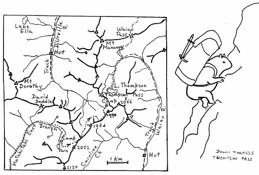
The next morning, on with the boots and off up the snow to end up back on the ridge a few hundred meters before the pass. On the east a straight valley headed directly down to the Waiau at a gentle angle, full of snow for a kilometer or so. However, to follow it would mean missing out on Lake Thompson, another really fine tarn, which was on the other tributary of the Waiau to the south. So after descending a couple of hundred meters I hopped over the little dividing ridge and headed down to the lake for breakfast.
EXCURSION 4: MOUNT FRANKLIN.
At 2340 meters, Mt Franklin is the highest peak in the Park, towering above Mt Travers's 2338 meters. It's easily accessible from the track along the West Sabine just below Blue Lake hut, which I had reached the morning before, a couple of hours after Bean and Dave left, from a wet camp at the head of Lake Constance after crossing Waiau Pass. I'd spent most of the day outside the hut cooking up a big bag of rice so as to save having to light a fire for the next few days (a real hassle in the beech forest unless the weather's been dry for a long time). Then, about three o'clock, just as I was thinking of heading off downriver, it started pissing down again, so I thought again. The hut library consists of three-quarters of a book, which I hadn't read yet, and this no doubt contributed to my decision.
Lying awake in the bunk that night it occurred to me that it would be irresponsible to leave the South Island without doing another climb. Next morning it was overcast, but the peaks were visible. Probably the cloud layer would drop later in the day, but maybe it wouldn't. So after some indecision, I throw my boots and axe and a bit of chocolate in my pack and set off at about eight o'clock. Blue Lake is dammed by an old moraine over which the river cascades, so that it's necessary to follow it down half a kilometer or so till it flattens out a bit and can be waded to get to the east bank. From there I walk across the flat through open beech scrub and ferns, cutting the corner to the creek which descends from the west face of the peak. This creek flows down a narrow gorge up which I scramble, under a waterfall where the creek enters the gorge from the right, and out into the wide scree-filled valley above.
I can see the scree stretching up a couple of kilometers to the foot of the long north-south summit ridge, with two or three scree-filled gullies reaching the crest of the ridge south of where the peak should be. I had been told it was best to take the northernmost gully, as the ridge south of there is a bit scrambly. The scree couldn't be classed as high quality, being mostly loose enough to slide underfoot going up, but with too many big rocks in it to be readily runnable coming down. There's nothing living in sight except a few vegetable sheep halfway up.
I sidle over to the creek for a last drink before it disappears under the rocks, and then head on up. I think I can see a gully which seems to go all the way to the top which looks like the right one. It's distinguished by a notch at the top which seems from down here to overhang from the south. I wander on up. The cloud level drops, but by the time the gully disappears I'm near enough to it so I shouldn't miss it. The scree gets steeper and looser. I sit down on a sheep for elevenses and put my boots on over my sandshoes.
There's a patch of snow below and to the left of my gully which is visible through the mist, so I aim for that. I climb up beside it and eventually get into the gully. Then I kick steps up the loose shit in the gully itself, mostly holding on to the rock along the edge to keep from slipping down again any more than necessary. I pass the overhanging rock I could see from below, and soon after reach the top of the ridge and am (presumably) overlooking the Travers valley to the east.
I'm just below the northern shoulder of the almost level crest which heads north to the summit. It's easy going up and along the ridge, though a bit further than I expected. After a few hundred meters there's a small cairn so I reckon that's the summit. The views are not exactly extensive. I eat my chocolate.
I head back along the ridge. It's not always clear which spur is the right one, and once I start down towards the Travers and have to back up till I find a footprint in the snow. Pretty soon I'm back at the notch at the head of the scree gully. I try to pick where the scree is loosest and head on down.
Running scree in the mist is a bit like night skiing without a moon. The world narrows in to maybe twenty yards radius and seems to go down forever. There's nothing to think about except whether to go straight down or slant a bit to the left or right where the scree might be finer and easier to get to run. I don't know how long it lasts -- probably only an hour or so. After all, there's only six hundred meters of vertical height involved.
Eventually the slope eases off and the rocks get larger and the slope on the north side of the valley comes out of the mist. I have to start thinking about where to put my feet, which is a bit tiresome. I sidle over the little ridge into the gorge, where, since I still have my boots on, I am able to go for the loose stuff up the side and slide down a good deal of the way, making a mess but avoiding the rockhopping along the bottom. Below the gorge, the creek bed flattens out and I take my boots off --- they're too stiff for comfortable walking on level ground. Down the grassy bank, through the bush, wade the river, up the track, back to the hut. It's about six o'clock. The cloud seems to be lifting again.
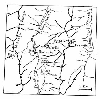
The next morning, I spend a couple of hours walking around Blue Lake, which is one of the nicer lakes around, and up to where the river reappears having flowed underground a kilometer or so from Lake Constance. Very impressive -- it's quite a big river. Then off down the Sabine, pausing for two or three hours at West Sabine hut to consume the two magazines in the hut library.